
For years, users have expressed a need to download topo maps covering entire states or countries.
As of 5.7.8, the method is being simplified.
Please see this link on your mobile device for these instructions.
http://www.openandromaps.org/en
(without the /en part, the site will be in German, if you prefer that)
Remember to bookmark this site and donate to it so that they can continue to produce great maps.
Installing a Style
Installing a style only has to be done once. We recommend the Elevate theme, version 2.X and will recommend Elevate 3.X when we are ready.
1. From http://www.openandromaps.org/en Go to Map Styles in the menu (the symbol that looks like :=) and choose Elevate Theme. You will end up at a link like this.
http://www.openandromaps.org/en/legend/elevate-mountain-hike-theme
2. Look at the Elevate 2.X theme (Elevate 3.X compatibility to come).
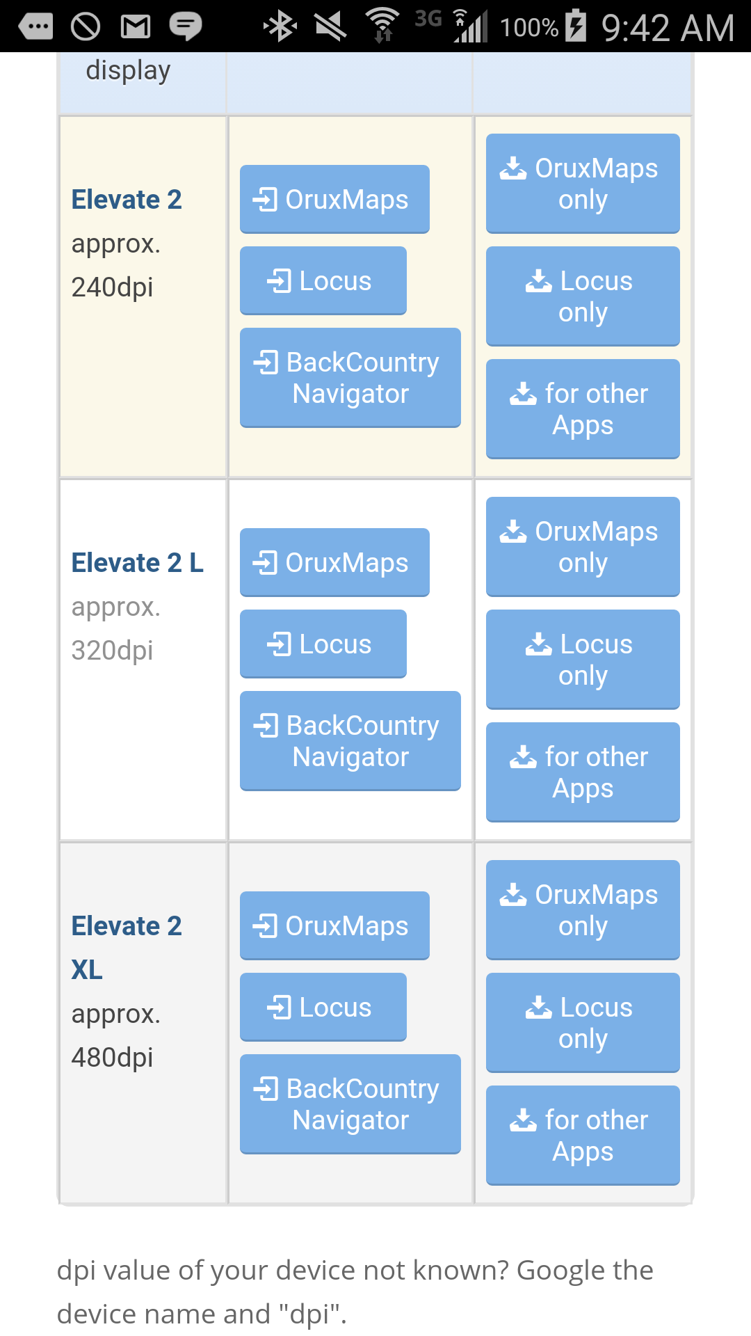
3. Find the row in the table that corresponds to your screen resolution. 240dpi is the resolution of many tablets. Hi res phones can either be 320 or 480 dpi. When in doubt, choose 320 dpi.
4. Push the button that says BackCountry Navigator. If nothing happens when you push this button, you probably don't have 5.7.9 of BCN or later. Go to Google Playstore app and look for updates.
5. You will briefly see a screen with a progress bar as we download the style.
6. You will see a screen that asks you to pick a style file:
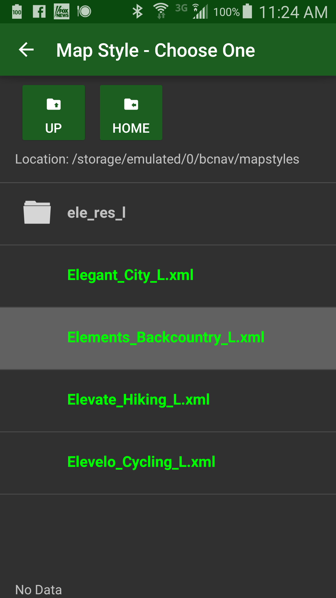
I pick BackCountry, even though its not affiliated with us. Hiking, Cycling, or City all might be good for you depending on the situation. You can change them later from the Layers menu.
For more information about the styles, including a PDF legend, see the page you just got the styles from:
http://www.openandromaps.org/en/legend/elevate-mountain-hike-theme
Downloading a Map
- Go to http://www.openandromaps.org/en. Book mark the site so you can donate to them later.
- Go to the Downloads menu. Choose a map from many countries or states. You will end up downloading something like Washington.zip. Yellowstone national park is a good choice if you want to practice with a small one.
- Open the + symbol for additional options. You will see an option called "Install on BackCountry Navigator".

4. A screen with a progress bar will appear. The download has not started yet till you confirm and press Install. (If nothing happens when you push this button, you probably don't have 5.7.9 of BCN or later. Go to Google Playstore app and look for updates.)
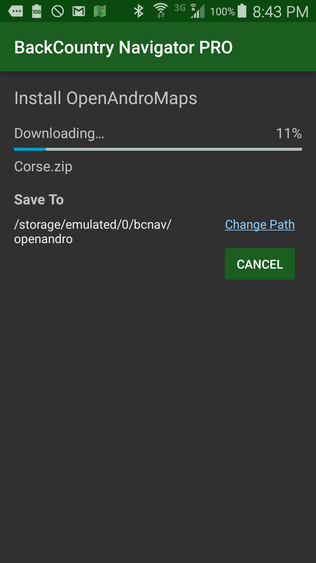
5. You have a chance to change where it is putting the map file, if desired. It is recommended that you pick a place, or our default one, and stick with it.
6. The download will begin after you confirm by pushing the install button.
7. When complete, the button will change to View. Push this to see the map.
When I finished, this is how my Layers Menu looks.
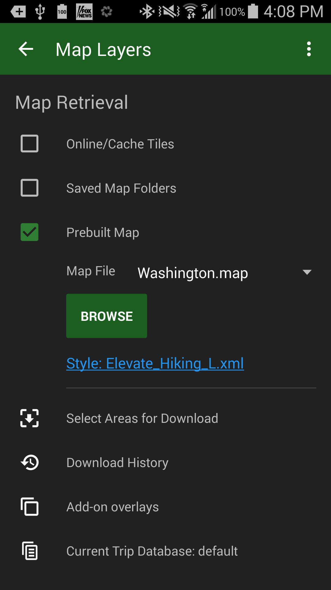
Note that the dropdown next to Map File contains the four most recently used maps.
After you have downloaded a map through this method, the "Browse" button will start in the location you chose for your maps. If you do install or move maps via another method, it is suggested that you put them in the same folder so they are all easy to find through browse.
This is how it looked in a nearby national forest:
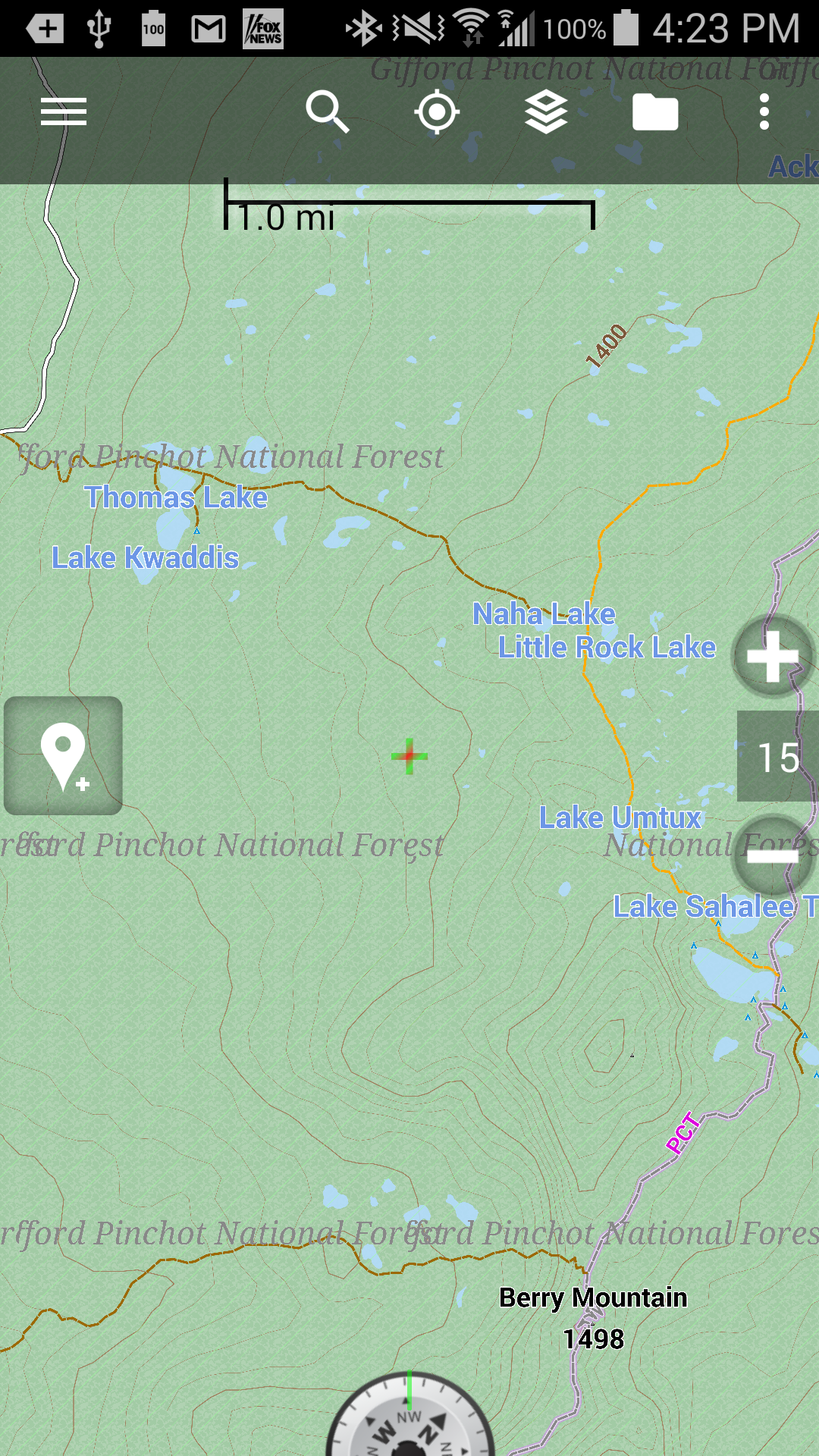
Take note about the
- Data for streets, trails, and just about everything are based on OpenStreetMap data, a community effort. Trails are based on the "walking path" component. I have found it to be quite good, and have trails that are not mentioned in other sources.
- Contours are in meters, not feet, which may be a disadvantage only to those who are in the United States. (or does some other country care about contours in feet?). Major contours appear to be every 100m and minor contours at 20m.
- It is still very important where the map is centered. If you load a map of Washington but happen to be hiking, or browsing, in Oregon, you will find that it comes out completely blank.
- These will render slower than raster map tiles, and need a bit more processing power.
Please do:
- Donate at the openandromaps.org/en site if you find these useful.
- Contribute your own data to the openstreetmaps.org project.
Please do not:
- Complain to us if the maps are not adequate for your need or are missing features you consider important. We do not own the data and neither do the hard working people at OpenAndroMaps.org. The data belongs to the people and you have the chance to contribute.
We will continue to make the process more streamlined.
Comments
50 comments
Thanks for the tips on large scale map downloads. My thinking might be backwards but I am always trying to figure out how much of Southern CA I can get on a 128 G SD card or on a 2 TB external drive. My 4 wheel tours can be spur of the moment (within perhaps a multi-county wide region) and I don't want to have to worry about sitting down and boxing my way thru a set of downloads specific for each trip. Understood this is different than needs of a thru hike on the PCT. So to me a "large" area is the size I can download into match my storage capacity. Memory is cheap and if I can store the maps on a HD and then dump them into my Android tablet when needed, works for me.
Well, now you could place all of California in 416 megabytes. Of course, you have to review it to see if the map is valid for your purposes.
Worked for me as well. Downloaded Washington, Oregon, Idaho, and California for a trip this summer. This is great, my Galaxy S5 has a 64gb card so bring it on with bigger and more details, woot! Thanks Nathan!
works like a charm for me, downloaded denmark and spain/portugal and put them in the atlas folder on my external sd-card.
I also create maps with the MOBAC program, using version 1.8 as it still have the microsoft satellite views available. I can choose my own zoom levels up to 19.
But the option that we try out here has the advantage that you can do it all from your mobile when you actual need the map.
Worked for me. I put the AZ/NM map (around 350megs) on my HTC One along with the elevateXL style. I did make a contribution to the map site.
Works for me, thanks Nathan.
Any idea why the diagonal green lines (screenshot) ? I don't see them in Nathan's example image.
Nexus 4 / Washington.map / Elevate L style
Screenshot_2015-03-08-09-53-57.jpg
perhaps it was used to delineate ownership, like an indian reservation. If you zoom out you might be able to tell if that's the case by the shape of the area with those lines.
@Jimntempe Yes, you are correct. It is over areas of National Forest and National Park. But, the areas also use the green background, so the lines are redundant. Not a big deal, but it does add unnecessary clutter IMO.
I wonder if it's the result of them using multiple databases to pull the underlying data from and that same boundary is in more then one database so it gets highlighted two different ways.
I can narrow this down. This is definitely coming from the theme. There may be a reasoning behind it, but I also find it undesirable.
One could probably remove the lines by altering the themes. Of course, knowing what to change involves understanding it a little bit.
Your right.
If you delete, or comment out the following rules in the xml files, the diagonal lines are removed.
<rule e="way" k="leisure|boundary" v="nature_reserve|national_park|protected_area">
<rule e="any" k="protect_class" v="1|~" zoom-max="13">
<area src="file:/ele_res_l/p_nature-reserve.png" />
</rule>
<rule e="any" k="protect_class" v="1|~" zoom-min="14" zoom-max="14">
<area src="file:/ele_res_l/p_nature-reserve_large.png" />
</rule>
<rule e="any" k="protect_class" v="1|~" zoom-min="15">
<line stroke="#909DFF9C" stroke-width="0.84" stroke-dasharray="18,6,6,6" stroke-linecap="butt" />
<area src="file:/ele_res_l/p_nature-reserve_x-large.png" />
</rule>
I missed 1 closing tag in the code snippet above. Should be:
<rule e="way" k="leisure|boundary" v="nature_reserve|national_park|protected_area">
<rule e="any" k="protect_class" v="1|~" zoom-max="13">
<area src="file:/ele_res_l/p_nature-reserve.png" />
</rule>
<rule e="any" k="protect_class" v="1|~" zoom-min="14" zoom-max="14">
<area src="file:/ele_res_l/p_nature-reserve_large.png" />
</rule>
<rule e="any" k="protect_class" v="1|~" zoom-min="15">
<line stroke="#909DFF9C" stroke-width="0.84" stroke-dasharray="18,6,6,6" stroke-linecap="butt" />
<area src="file:/ele_res_l/p_nature-reserve_x-large.png" />
</rule>
</rule>
Does anyone know if maps from this State of Michigan site will work on this app? http://www.michigan.gov/dnr/0,4570,7-153-10371_14793_55471-38330--,00.html#evart_motorcycle_trail When I download one of the maps it shows in GPX, KML and SHP format. Not the most technical guy. Thanks
We are using 2.X style and will support 3.X in a week or two, I believe.
Openandromaps is a great addition. It was fairly simple to download before the recent changes but now it's even easier with the "backcountry navigator " button.Of course these maps aren't as detailed as the other BC maps given the file size but they are invaluable when you find youself out of internet range plus having the whole state downloaded is great. It's nice to have it on BC because I can use all of the great tools offered by BC. I'm looking forward to Elevate 3 and the advances it will bring.
Thanks to Nathan and the crew for a fantastic job in responding to the requests of BC users.
Kar2run, are you sure that you have the latest version on the tablet?
Is there more that one browser on the tablet? Its possible that one of the browsers won't honor our registration. I would try Chrome if you know you are up to date.
Post up when 3x is ready. I briefly played with 2x last night but will wait for the update before I build a mapset. I like to have the options you offer with standard offline maps. Aerial imagery is nice in the back country especially above treeline.
I was able to down load it on my galaxy tab pro 10.1 as well as my s5. I messed up on my first attempt so I had to go to my files and erase the incorrect file in BC navigator and then make a second attempt which was successful. I can't remem
whoops, sorry for not completing the above.
As noted above i went to "my files">device storage>bcnav and then to mapstyles and erased my earlier attempt. If it's not in map files it may be in"atlas'.
Once you've erased it then go back and go back to syle page on openandromaps and try again to download the elevate 2 with the bc naigator button. I used the elevate 2L 320dpi and it worked fine. I'm not sure about the XL on the galaxy tab.
I just downloaded some OpenAndroMaps and they are pretty decent. Just sent a donation to them too. Hoping the 3x will be even better.
Am having a problem though. I have lots of room on my new Samsung Tab A, 9.7" so downloaded CA, NV, OR, UT&CO and AZ. They're all there in the bcnav atlas file, but only four of them show up when I go to" MAP LAYERS, PREBUILT MAP, MAP FILE.
What happened to the fifth one??
Nothing happened to the fifth one. The menu just shows the four most recent used. There is also a browse button on that page.
Thanks for the quick reply Nathan. Yeah I saw, and tried, the Browse button but it took me to a different screen and I couldn't find any way to locate my downloaded maps. I just spent more time clicking options in that area and found where the maps are located and am now able to access them.
I guess my only comment, other then thanks for making this all available, is to allow more than four to be able to show on the drop down menu on the Map Layers option.
LOVE BCN!!!!!
I would agree that map choosing can be a little convoluted. Especially when you don't use the app every day.
One thing in particular, is that if you use the Browse button, or even select MORE MAP SOURCES > USE MOBILE ATLAS it opens to the Download folder, not the BCNAV / ATLASES folder. A few clicks later you are in the correct location to choose another option. I don't know about other devices, but the file structure on the Nexus 4 is convoluted itself so users can get lost in what should be an easy process.
On another note, I was using the app in the car a while back and noticed my location wasn't moving. I restarted the app and it updated to my real location. Had I been on foot, It would have been much longer before I noticed (the icon status did not change). Perhaps a notification could be added that would alert the user if gps location is interrupted for any reason.
Thanks!
If I may comment here.
Your OpenAndroMap downloads may be spread out because of a failure to standardize when this was a beta.
Downloads is a reasonable place to look for things that people have downloaded straight from the internet. Moving files from computer to phone is a rather advanced case for many.
The intention now, is that if you use Install on BackCountryNavigator as above, that you will choose a place, or use our default, and put all maps on there. Once that is done, the browse button should open to that location.
I recommend that if you have put maps in a different place in the past, that you install at least one using this button and move all your maps there. The same with styles.
Your comments are always welcome, of course!
Is the default loactaion: bcnav/atlases
Please sign in to leave a comment.