
We are excited to announce a new, premium Map Source in partnership with AccuTerra.
Accuterra is already well known on the iPhone and is the same data offered on Magellan GPS
Compared to other free sources for the continental United States, these maps offer better contrast, better shaded terrain, and more up to date roads and trails.
PLEASE NOTE: Some users reported missing overlay tiles in East Tennessee and surrounding areas. You can now get around this by activating the AccuTerra Data Scale Setting in 4.5.3.
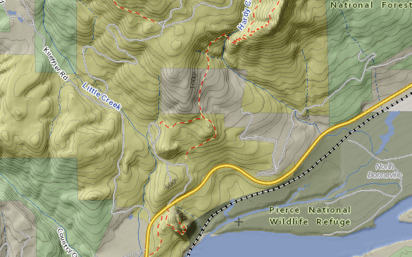
This is a multilayer map source, the first one of its kind in BackCountry Navigator. The three layers are:
- Land: topographic contour lines, water features, and colored according to type of land.
- Terrain: 3D like shading based on slope.
- Data: Roads, trails, boundaries, and other linear features drawn on top of the terrain.
No need to worry about what you get with this map source. With your tablet or desktop computer, you can preview these at
PLEASE NOTE: the app can zoom farther in than you will see on the web based DEMO. This is a limitation of ERSI web map technology that does not exist in BCN.
This setting is for those who experienced X's instead of trails in East Tennesee, etc.

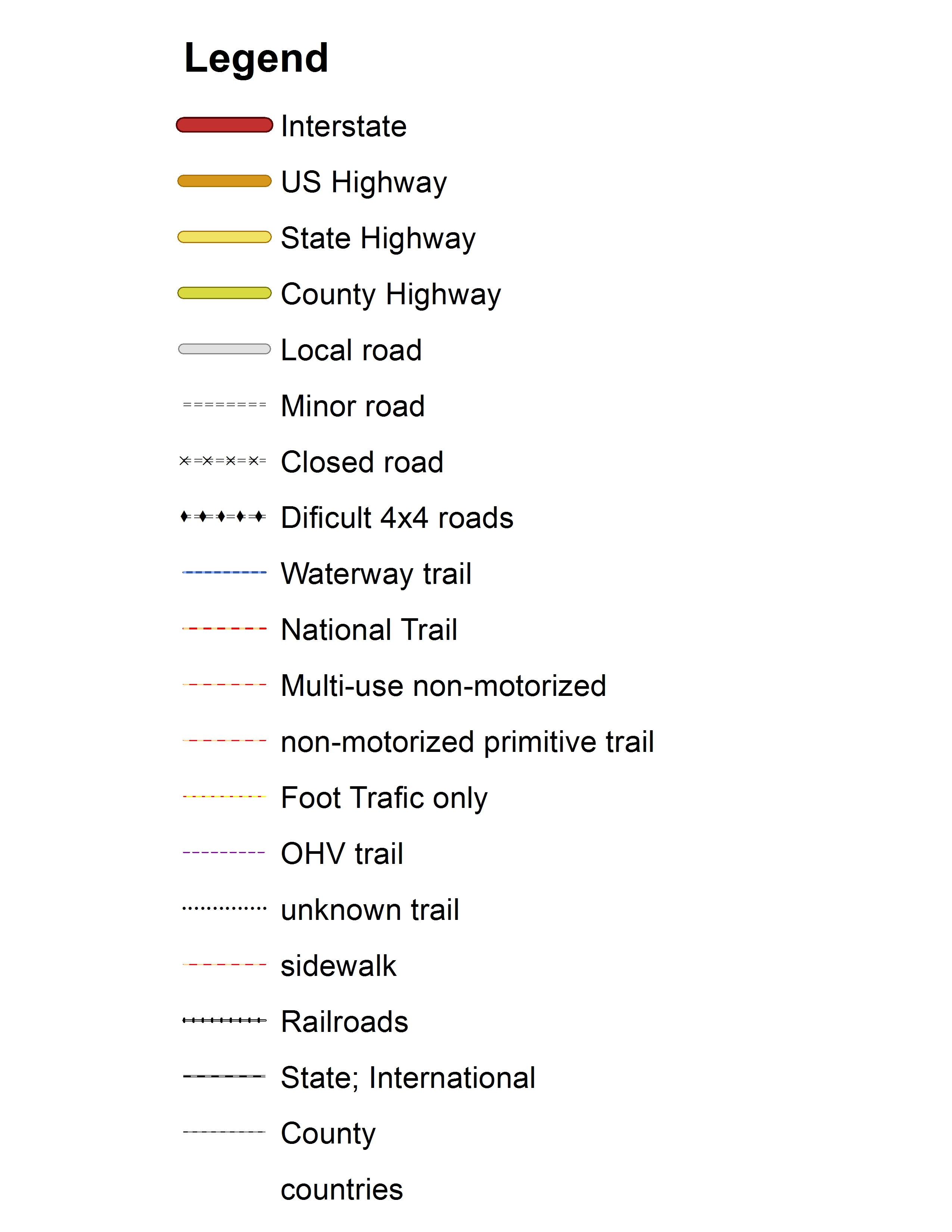
This is the legend for land and water features:

This is the legend for data:
Comments
60 comments
Awesome, finally have trail maps!
Here are some things you should know.
You do need to update to 4.5.1 or later of BCN. Please do this *before* purchasing. Earlier versions can show this purchase but they will not process this properly.
(note: if you did buy before updating to 4.5.1, you can probably use the restore purchase button after updating to set things right).
http://support.crittermap.com/entries/20519998-seeing-version-and-updating
You can purchase it through the addons menu.
The accuterra map source is not an overlay, so don't look for it in the overlays menu. In contrast, go to the Maps Menu and choose "More Map Sources".
Then look for a button that says AccuTerra Map Source (premium).
You should soon see the map, as long you are centered within the continental US:
The BEST so far, especially for prospecting.
you mentioned that accuterra is multilayered.. is there a way to turn off some layers? i notice some lagging when panning around. thanks
Not at this time, sorry. It will be faster if you have predownloaded. Which layer didn't you want -ground, terrain, or trails?.
You may be able to find the legends in the Gallery app on your phone. It will be in an "album" called "bcn_p_mapsrc..." or something like that.
Awesome! Shows trails that I never knew existed. Great graphics too. Keep it up!
I hesitated for a while, and am really happy I took the plunge. I loved it after two minutes. Clear, fast and great trails. One issue after a few hours of playing. I installed to my RAZR MAXX and now want to try it on my tablet for the "big picture". How do I transfer or uninstall and reinstall?
Thanks for one of my favorite Apps.
Any idea when the map problem in eastern Tennessee will be fixed? My wife and I are going backpacking in near Tremont in GSMNP June 12-14 and I would like to use the new maps.
Nathan, Disregard my previous questiion about reinstalling. It took me a while to figure out that "Restore Previous Purchases" is in-app and not in-Google Market (Oops ... Play). I'm slow, but not out of the game yet! Although I have become quite curious about the add-on purchase. If the Add-on is purchased through Google, why doesn't is show in the My Apps section in the marketplace?
> If the Add-on is purchased through Google, why doesn't is show in the My Apps section in the marketplace?
That's a question for Google, but at the moment, all in app stuff is handled, well, in app. I would like it to be more visible, but it isn't.
Having trouble viewing AccuTerra maps. I have a Samsung Galaxy S 2. I am running BCN ver. 4.5.2. No trouble viewing any other map sources. I have uninstalled and reinstalled BCN and did 'Restore Purchases' for Accuterra and got the message: ‘AccuTerra Map Source Unlimited installed’ quite a few times now. All I am seeing is the grey screen with the x's. I tried downloading a portion of the map and get a message: 'Downloading:Accuterra Land 0% of 696231-Retries:842' I got 8% once but every other time it stayed at 0%.
Any help would be greatly appreciated.
Your storage is likely full.
696231 is a big number - this could easily be 6 Gigabytes. We do not recommend state size downloads as they won't fit.
If that doesn't help, consider sending a log so we can see the error messages.
I just purchased BCN 4.5.2 and the AccuTerra Maps Unlimited in preparation for a trip to the Cohutta Wilderness for a couple of weeks of hiking. The Online demo shows trails marked on the map, but I can not find how to show the trails on my Android Galaxy Note. How do I get these to display?
Nothing special, but there is a problem in the Tennessee area, affecting the trails and roads layer. AccuTerra is working on it as their highest priority.
Any ETA on a resolution. I hate to say it, but I just spent a lot of money on this thing, and the location I am going to doesn't have the data I need to work.
I don't have a definite timeframe from them. I will release a workaround for you all this week if I have to.
Wow, that is a pretty good response. Thank you
Nathan,
I was able to download a smaller map. I couldn't see what I was highlighting so I obviously highlighted too much. But still can't view the maps.
Here is a log file.
Thanks for the help.
andersen.txt
This is the setting you need in 4.5.3.
I purchased Accuterra with BCnav 4.53 on a Droid X. Neither the preview nor the download are working. I refreshed my purchase and restarted my phone. I'm in Olympia WA trying to download tiles in Olympics and Alpine Lakes. Any suggestions?
IT is working today after they told me they restarted the server.
If you know something is an AccuTerra issue, and not a bug or a full storage card, you can contact support@neotreks.com.
Greetings, Just bought AccuTerra and unfortunately I am not seeing any map data. I centered the map in Colorado and have tried various zoom levels and other states. Just getting the gray X's. I have AccuTerra selected as my map source. I tried Restoring Purchases and also selecting AccuTerra Data Scale. I tried Preview On and Off. I rebooted my phone. I'm out of ideas. Any suggestions? (Razr Maxx, BackCountry Navigator PRO version 4.5.3). THANKS!!
I didn't realize that there was a problem request system. I put in a ticket and Nathan responded quickly.
PROBLEM SOLVED! It was an issue with the AccuTerra server and nothing to do with the CritterMap software.
Thanks Nathan!
I just bought BCNav (good program, happy with it) and have downloaded mytopo.com maps, which are pretty good. However, I am not that thrilled with the download process and how to choose what to download. Also, don't like that I can't save to my external SD as I will run out of space otherwise. Question, before I buy, I would like to know what the download process is for the Accuterra Maps. Hopefully I can select large grids so I don't have to patch many, many downloads to get a large area or state (this process is much easier to do on my Garmin). For $20, I'm hesitant to purchase before seeing how this goes. It would be nice to have demo of this. Also, any word on saving maps to external SD?
Article is closed for comments.